Flood risk lower than in 2011: Ashton
Advertisement
Read this article for free:
or
Already have an account? Log in here »
We need your support!
Local journalism needs your support!
As we navigate through unprecedented times, our journalists are working harder than ever to bring you the latest local updates to keep you safe and informed.
Now, more than ever, we need your support.
Starting at $15.99 plus taxes every four weeks you can access your Brandon Sun online and full access to all content as it appears on our website.
Subscribe Nowor call circulation directly at (204) 727-0527.
Your pledge helps to ensure we provide the news that matters most to your community!
To continue reading, please subscribe:
Add Brandon Sun access to your Free Press subscription for only an additional
$1 for the first 4 weeks*
- Enjoy unlimited reading on brandonsun.com
- Read the Brandon Sun E-Edition, our digital replica newspaper
*Your next Free Press subscription payment will increase by $1.00 and you will be charged $20.95 plus GST for four weeks. After four weeks, your payment will increase to $24.95 plus GST every four weeks.
Read unlimited articles for free today:
or
Already have an account? Log in here »
Hey there, time traveller!
This article was published 28/02/2013 (4850 days ago), so information in it may no longer be current.
The worst-case scenario for the Assiniboine River is moderate spring flooding this year, according to the province’s flood outlook released Wednesday.
Steve Ashton, Manitoba’s emergency measures minister, said the flood risk for the province is higher than last year, but still a far cry from the 2011 levels.
“The big difference between this year and 2011 is that there’s not a significant amount of moisture content in the soil that we were faced with in 2011,” Ashton said. “We’re not at the 2011 flood risk, but there still is some flood risk.”
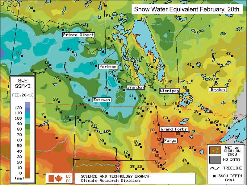
Minor to moderate flooding is likely along the Red, Souris, Pembina and Assiniboine rivers, and in the Interlake region.
“We have had some significant precipitation in North Dakota, Saskatchewan and Manitoba,” Ashton said. “A lot of this will depend on the weather over the next period of time. The most significant month that we always look for in terms of moisture content, whether it’s the snow or rain … is actually in March going into April.”
Ashton said the province will be watching the storm activity very closely. Much depends on the weather over the next several weeks, how quickly the snow melts, whether major dumps of snow or rain occur at the same time as the melt and whether unpredictable ice jams develop.
The preliminary flood outlook comes as a relief to Mayor Shari Decter Hirst.
“It seems like we’ve got a lot of snow, but … because it was so dry in the fall, there is a lot of capacity for the ground to absorb the melt,” Decter Hirst said. “So … as long as we don’t get any abnormal snow storms, we should be good.”
The Shellmouth Reservoir on the Manitoba/Saskatchewan border is used for flood control on the Assiniboine River.
Steve Topping, executive director with Manitoba Infrastructure and Transportation, said they are drawing Shellmouth down to “historical low levels, similar to the 2011 level.”
“This is to accommodate run-off from the upper watershed in Saskatchewan,” Topping said.
The Assiniboine River, between Shellmouth and Brandon, will likely experience similar conditions to those of 2012, Topping said.
“There is expected to be minor flooding, over-bank flooding, if we get the normal weather or adverse weather scenario,” he said.
Since the historic flood of 2011, the City of Brandon has been planning for three permanent dike systems, along 18th Street, First Street and the Assiniboine River corridor.
“What we need to do is, instead of having the giant wall of sand bags right next to the road, we’re pushing the dike back a way from 18th and First (streets), so we don’t have to close those roads down …should we ever be in a circumstance where we’ve got high water like 2011,” Decter Hirst said.
The mayor anticipates “taking a great leap forward” on the project this summer.
Other flood protection work that has been done since 2011, is reinforcing the river’s dogleg near Dinsdale Park, as well as work on the Hilton Lift station.
Meanwhile, it appears those near the Souris River will be at risk of minor to moderate flooding as well.
According to the province, minor flooding occurs when water reaches a height at which some property along the edge of the water might be damaged or at risk. To qualify as minor flooding, there must be some potential danger to the public.
Moderate flooding includes flooding of low-lying roads and structures. At this stage, it might be necessary to move some people and their belongings to higher ground.

“The snow pack once again is very high in Saskatchewan, but the soil moisture conditions are low,” Topping said. “So definitely, the Souris will not see levels that is saw in 2011 … communities like Melita and Souris can deal quite easily with the flood that we had similar in 2009 and we’re not forecasting 2009 level floods on the Souris.”
Farmers downstream from the Shellmouth Reservoir are worried the province’s outlook is underselling the potential for flooding in the Assiniboine River valley.
Stan Cochrane, president of the Assiniboine Valley Producers, said he’s hearing that Saskatchewan has significantly more snow than Manitoba in the watershed area that feeds the Assiniboine River.
“The big thing is we don’t get flooded from local water,” Cochrane said. “Local flooding happens in April and it goes away and then you seed your crop. The water we get that causes us a problem is the same water that gave us a problem in 2011 and 2012 — it’s all going to come from Saskatchewan.”
Furthermore, the lack of substantial regulations to prevent drainage in Saskatchewan is compounding the problem, according to Cochrane.
“They don’t have the regulations in Saskatchewan that we have in Manitoba. They’re just draining it as fast as they can drain it and it’s been accelerated lately because Saskatchewan is admitting they have to do something about their drainage problem … in the meantime the guys are saying: ‘Let’s get this water drained before they bring in regulations that say we can’t do it.’”
He is pleased with the province’s decision to bring the level of the Shellmouth Reservoir down to one of its lowest levels ahead of the spring thaw. Cochrane said the reservor is at a height of 1,490 feet, about four feet above the reservoir’s historic low point with the goal of releasing more water to get there. At its full supply, water starts going over the spillway at 1,408.5 feet, and Cochrane said it will be important to monitor and control how much water is being released so the reservoir can do its job and serve as a flood control mechanism.
However, until the drainage problems in Saskatchewan are fixed, Cochrane believes the Manitoba government is fooling itself thinking they can accurately predict flood outcomes. He’d like to see the province take a harder line when it comes to dealing with our neighbours to the west.
For his part, Ashton said the province is in constant communication with Saskatchewan, but he also ceded that illegal draining in Saskatchewan is a problem.
“We’re concerned about any impacts that can be seen in Manitoba in any year, whether it’s a flood or not and we’ve raised that concern (with Saskatchewan) at every level from the political through to the official,” Ashton said. “That’s not to suggest that in 2011 when we had major flooding that (illegal draining) was the cause of the flood.”
Without proper oversight, the problem will continue to plague Manitoba and its flood mitigation efforts.
“When you have illegal drainage what it does is it shifts impacts from one property to another and from one community to another and really that’s not acceptable,” Ashton said. “We feel it’s important to have appropriate enforcement and licensing when it comes to drainage (in Saskatchewan).”
» Brandon Sun