Flood update: Lagoon swamped in Melita, pressure on in Oak Lake
Advertisement
Read this article for free:
or
Already have an account? Log in here »
We need your support!
Local journalism needs your support!
As we navigate through unprecedented times, our journalists are working harder than ever to bring you the latest local updates to keep you safe and informed.
Now, more than ever, we need your support.
Starting at $15.99 plus taxes every four weeks you can access your Brandon Sun online and full access to all content as it appears on our website.
Subscribe Nowor call circulation directly at (204) 727-0527.
Your pledge helps to ensure we provide the news that matters most to your community!
To continue reading, please subscribe:
Add Brandon Sun access to your Free Press subscription for only an additional
$1 for the first 4 weeks*
*Your next subscription payment will increase by $1.00 and you will be charged $20.00 plus GST for four weeks. After four weeks, your payment will increase to $24.00 plus GST every four weeks.
Read unlimited articles for free today:
or
Already have an account? Log in here »
Hey there, time traveller!
This article was published 21/04/2011 (5492 days ago), so information in it may no longer be current.
Melita’s dikes are holding back the Souris River, but a sewage lagoon was overcome by flood water, provincial flood officials said in a daily flood briefing in Winnipeg.
“Down stream, residents have been told of the inundation of the sewage lagoon,” said Steve Topping, Manitoba Water Stewardship’s executive director for regulatory and operational services.
“This does not disrupt the sewage service to the town.”
This will not affect the town’s drinking water, as most Manitoba towns use underground sources to get drinking water, Manitoba emergency services minister Steve Ashton said.
The sewage lift station, located closer to the junction of Highways 3 and 83 north, remained dry behind two sets of dikes and a sandbag wall. If all three flood protection layers are defeated, the town will have to be evacuated, though this is not expected.
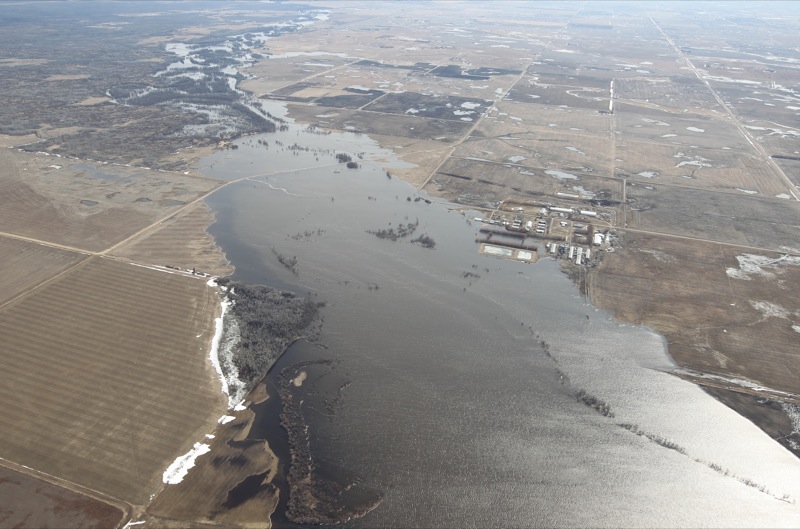
While the normally meandering Souris River, aerial photos now show the river flows through one large channel kilometres wide in some spots.
Topping said the crest of 430.21 metres above sea level, save for minor increases, has arrived on the Souris at Melita, but the volume of the water coming from North Dakota and Saskatchewan will ensure that crest lasts as long as six days. Unless there is a significant snow or rain storm, a second crest is not expected, Topping said.
Sandbagging efforts are underway at an ice-covered Oak Lake, where incoming water from the Pipestone Creek at 3,200 cubic feet per second has put pressure on lower-lying cottage properties. The dam is releasing water at 1,200 cfs.
“The biggest problem we have on the lake is at Oak Island Resort,” said Rick Plaisier, reeve of the RM of Sifton. “We’ve had to sandbag four different cottages, two which are year-round residences. We had 50 or more people out to do it. That will be enough to save the residences.”
Plaisier said Oak Lake is rising five-to-seven centimetres per day because of Pipestone Creek. The dam at Plum Creek is still intact.
“There’s a lot of rumors going on that the dam is damaged and it’s not,” Plaisier said. “We were up in a helicopter twice and it’s fine. There is a little bit of a breach on the west dike near Pipestone Creek, but it’s not a serious one.”
When the ice cap on Oak Lake melts, wind could send ice chunks to the shoreline, which could some damage cabins.
At the Maple Grove Hutterite Colony, 19 kilometres southwest of Hartney, water has swallowed up some more land, but has not threatened barns to residences. A well house, which is completely surrounded by as much as 400 metres of water in any direction, was tarred and wrapped with plastic are remains in use.
“The water’s gone up six inches here since Tuesday and we have people going out to the well house (by boat) to pump out the dike there, but we are still getting our water from there,” said Joe Waldner, the colony’s secretary. “We have a boil advisory for safety. We’d rather be safe than sorry.
The colony, which has the provincial sandbagging machine, has sent sandbags to Souris, where rain showers and an anticipated crest has residents working to shore up dikes.
Topping said the water levels are 414.07 metres above sea level at Souris, with an anticipated crest of 414.49 metres to 415.08 metres within a couple of days.
Brandon Sun photographer Bruce Bumstead took to the air on Thursday, April 21, to document the extent of the flooding, as Westman braces for their rivers' crests.