‘Fairly pleasant’ weather forecast for next week
Advertisement
Read this article for free:
or
Already have an account? Log in here »
We need your support!
Local journalism needs your support!
As we navigate through unprecedented times, our journalists are working harder than ever to bring you the latest local updates to keep you safe and informed.
Now, more than ever, we need your support.
Starting at $15.99 plus taxes every four weeks you can access your Brandon Sun online and full access to all content as it appears on our website.
Subscribe Nowor call circulation directly at (204) 727-0527.
Your pledge helps to ensure we provide the news that matters most to your community!
To continue reading, please subscribe:
Add Brandon Sun access to your Free Press subscription for only an additional
$1 for the first 4 weeks*
*Your next subscription payment will increase by $1.00 and you will be charged $20.00 plus GST for four weeks. After four weeks, your payment will increase to $24.00 plus GST every four weeks.
Read unlimited articles for free today:
or
Already have an account? Log in here »
Hey there, time traveller!
This article was published 20/12/2024 (468 days ago), so information in it may no longer be current.
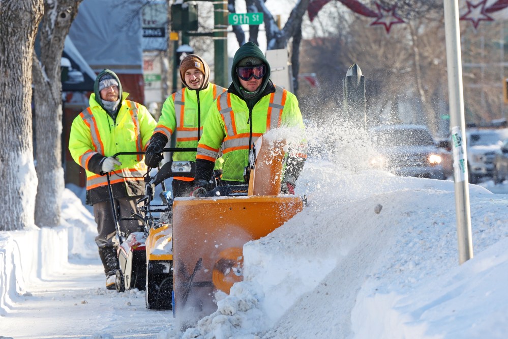
Following heavy snowfall during the last two weeks, the Wheat City’s weather is about to take a turn for the better.
Temperatures next week, including on Christmas Day, promise to be three times warmer than normal, according to Stephen Berg, a meteorologist with Environment and Climate Change Canada.
A total of 30 centimeters of snowfall was registered in Brandon during the last two weeks.
Berg said the second spell of heavy snow that hit western Manitoba on Wednesday night and conntinued into Thursday morning, was pushed in by an Alberta Clipper. It’s a fast-moving low-pressure system that formed in southern Alberta between Calgary and Lethbridge and raced east.
“It sprung up or developed over the foothills, got carried by the mid and upper-level flow and clipped southern Saskatchewan on its way towards us, with wind gusts up to 61 kilometres per hour,” said Berg.
“Looking back, at about two o’clock Wednesday afternoon it was over the southeast part of Saskatchewan. And Thursday afternoon, it was actually over the Minnesota-Wisconsin border, so it raced down quite quickly that distance over about a 24-hour period,” he said.
A Clipper can be massive in size, Berg added, but this one he said was, “a little bit on the smaller size for low-pressure systems.”
“I think at about seven in the morning (Thursday), it was probably about 300 kilometers, maybe a little bit more — from side to side,” he said.
The amount of snow that was dumped in the last 24 hours in and around Brandon, was an average of about 10 centimeters, according to Environment and Climate Change Canada weather stations and volunteer observers who reported their findings.
Within city limits, Brandon received 12 centimeters of snow, while measurements at the airport showed nine centimeters. Communities south and east of Brandon, such as Miami and Altona each received 18 centimeters.
Take the 18 centimeters from last Monday’s storm and add it to the recent 12, and you get 30 centimeters in nine days.
Yet, Berg said, December’s snowfall has “not been remarkable.” Brandon usually gets 29 centimeters of snow during the last month of the year, and the drifting created by the high winds can throw off consistent measuring, Berg added.
But what stands out when it comes to November’s precipitation, said the meteorologist was the amount of rain that fell. Brandon recorded six times more rain than normal.
The normal amount of rainfall for November is 3.7 millimeters, compared with 20.3 millimeters that was recorded. Add that to the 20.6 centimeters of snow, and November will go down in the record books as “quite a wet month,” Berg said. “And it was actually very warm up to the end, to the last week of November, and then it took a turn for the cold.”
Berg said to expect a few flurries tonight into Saturday morning, and then a pattern of milder weather will settle in for at least seven days.
The normal daytime high for next week is -11 C. Sunday and Monday will see temperatures around -9 C, and then Tuesday, which is Christmas Eve, it should warm up to -4 C.
“The long-range high for Christmas Day is -3 C, so that’s approximately eight degrees above normal,” Berg pointed out.
Brandonites will also get a break when it comes to the overnight lows of -20 C that are usually recorded this time of year. Next week, temperatures are only expected to dip down to between -8 C and -10 C.
“We have a fairly pleasant week coming up,” Berg said because of an air mass from the south.
“It’s from the mountain-west part of the Northern United States, so generally a southerly, southwesterly flow near the surface for a little while after this weekend,” he said.
“So, it’ll be more of a ridge over Brandon, keeping the cold air at bay.”
» mmcdougall@brandonsun.com
» X: @enviromichele