Most flood preparations complete in First Nation as it braces for rising water
Advertisement
Read this article for free:
or
Already have an account? Log in here »
We need your support!
Local journalism needs your support!
As we navigate through unprecedented times, our journalists are working harder than ever to bring you the latest local updates to keep you safe and informed.
Now, more than ever, we need your support.
Starting at $15.99 plus taxes every four weeks you can access your Brandon Sun online and full access to all content as it appears on our website.
Subscribe Nowor call circulation directly at (204) 727-0527.
Your pledge helps to ensure we provide the news that matters most to your community!
To continue reading, please subscribe:
Add Brandon Sun access to your Free Press subscription for only an additional
$1 for the first 4 weeks*
- Enjoy unlimited reading on brandonsun.com
- Read the Brandon Sun E-Edition, our digital replica newspaper
*Your next Free Press subscription payment will increase by $1.00 and you will be charged $20.95 plus GST for four weeks. After four weeks, your payment will increase to $24.95 plus GST every four weeks.
Read unlimited articles for free today:
or
Already have an account? Log in here »
PEGUIS FIRST NATION, MAN. – Sandbagging efforts are complete in Peguis First Nation and residents are playing a waiting game to see if the nearby Fisher River causes extensive flooding.
“Today and tomorrow (are) big days to watch and see what happens, and to see how high it’s going to go,” Doug Thomas, spokesman for the First Nation, said on Thursday.
The community, located in Manitoba’s Interlake region, has spent nearly two weeks prepping for an anticipated flood that could wash out critical roads and threaten more than 100 homes.
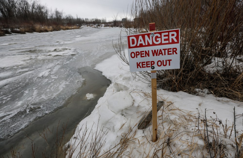
Water levels from the Fisher River began to exceed its banks on Thursday, said Thomas. It is expected to completely crest by Friday, which could see water make its way through the whole community like a wave.
Thomas said levels are supposed to subside after Saturday.
The province’s latest flood update posted Thursday says the Icelandic and Fisher rivers are under a flood warning, with water exceeding bank levels in some locations.
Officials initially estimated more than 200 homes would need to be sandbagged, but that number later dropped to 115. Some homes originally included in the list are condemned due to previous floods, said Thomas.
Crews will have to monitor the existing sandbags to make sure they are holding back water. Any leaks that breach the barrier will have to be pumped out.
More than half-a-million sandbags have been sent to Peguis and the nearby Fisher River Cree Nation, provincial officials have said.
The community is now working to construct clay dikes around two subdivisions.
Two roads in the First Nation are closed due to washouts, but it has not affected travel throughout the community.
Nine residents with medical needs were sent out of the community earlier this week as a precaution.
Thomas said as long as road access in Peguis is not cut off, he doesn’t anticipate any additional evacuations.
The community, considered the largest First Nation in Manitoba, has more than 10,000 members. Data from the federal government suggests roughly 3,800 live on the reserve.
Peguis has dealt with several floods in recent decades. In 2022, hundreds of homes were damaged and some 2,000 residents were forced to flee.
Hundreds of people from the provincial government, non-profits and the Canadian Red Cross have been in Peguis over the past two weeks to help with flood mitigation efforts.
Thomas said morale is high in the community, but long-term flood prevention is needed.
“Spirits are really good, and I think it’s because they don’t know anything else,” he said. “This is our way of life. It’s normal for us to be going through this every year, which it shouldn’t be.”
The community was relocated in 1907 — from good farming land close to Winnipeg to its current location on a flood-prone river delta — under a surrender of land to the federal government later deemed illegal.
Leadership from Peguis, the province and the federal government have hinted that a long-term solution is on the way.
Elsewhere in the province, the Assiniboine River continues to be under a flood warning as melting snow passes through the system.
The province said overland flooding may occur in low-lying areas, as warmer temperatures help melt the remaining snow.
This report by The Canadian Press was first published April 23, 2026.
— By Brittany Hobson in Winnipeg.