
Brandon ready for rising river
Advertisement
Read this article for free:
or
Already have an account? Log in here »
We need your support!
Local journalism needs your support!
As we navigate through unprecedented times, our journalists are working harder than ever to bring you the latest local updates to keep you safe and informed.
Now, more than ever, we need your support.
Starting at $15.99 plus taxes every four weeks you can access your Brandon Sun online and full access to all content as it appears on our website.
Subscribe Nowor call circulation directly at (204) 727-0527.
Your pledge helps to ensure we provide the news that matters most to your community!
To continue reading, please subscribe:
Add Brandon Sun access to your Free Press subscription for only an additional
$1 for the first 4 weeks*
- Enjoy unlimited reading on brandonsun.com
- Read the Brandon Sun E-Edition, our digital replica newspaper
*Your next Free Press subscription payment will increase by $1.00 and you will be charged $20.95 plus GST for four weeks. After four weeks, your payment will increase to $24.95 plus GST every four weeks.
Read unlimited articles for free today:
or
Already have an account? Log in here »
The Assiniboine River is expected to start rising again today, with an expected peak on Monday, Brandon Mayor Jeff Fawcett said.
Residents are being encouraged to prepare a “go-bag,” with essentials like clothes, medication, identification and chargers as a precaution, he said.
“Currently, there is not an evacuation order, but the city continues to monitor conditions closely and is taking every possible measure to protect homes, residents and infrastructure,” Fawcett told reporters in a Teams call Wednesday morning.
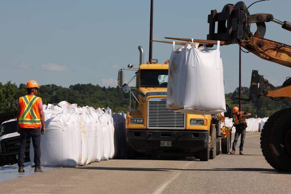
Workers move super sandbags into place along the southbound lanes of First Street North by Dinsdale Park in Brandon on Wednesday to create a dike as part of flood preparations. (Tim Smith/The Brandon Sun)
City crews were sandbagging and using other tools like tiger dams to keep water away.
Fawcett said residents will be alerted of an evacuation order through the province’s alert ready system, local media, the city’s communication channels and door-to-door notification.
The most likely places for an evacuation order to go out are for homes near the river.
“Residents are encouraged to familiarize themselves with evacuation procedures,” Fawcett said. “Be ready because things can change.”
He said notices will be going out to about 4,000 to 5,000 residents in the next few days for information on what they should do if an evacuation is called.
Nevertheless, Fawcett said he has a “high level of confidence” in the infrastructure in place.
As long as the weather forecast doesn’t change, he is confident the city can manage the water that is supposed to flow through the city.
The water on Wednesday was at 1,171.9 feet, Fawcett said, and will rise about seven to eight feet by Monday and stay near that level for a few days before receding gradually.
That peak figure compares to the 1,185-foot peak during the 2014 flood, and the about 1,183-foot peak of the 2011 flood.
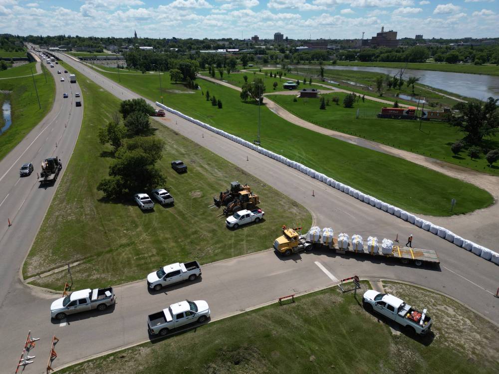
Workers install super sandbags along the southbound lanes of First Street North by Dinsdale Park in Brandon on Wednesday to create a dike as part of flood preparations. (Tim Smith/The Brandon Sun)
He said one of the reasons the city declared a state of emergency over the weekend was so that “if things have to happen fast, they will, and we will act on them. We’re controlling everything we can control, and it’s the things that we can’t that we’re going to be ready to adapt to.”
He told people to stay away from the water, as it can be more dangerous than it appears. Residents should also stay away from overland flooding, the dikes and stay off closed trails.
Fawcett said flood preparation work is also continuing at the Wheat City Golf Course on the west side of the community and at the Canada Packers Sports Complex on the eastern edge.
Provincial crews on Wednesday could be seen placing super sandbags along First Street North near the river and off of Grand Valley Road near the Trans-Canada Highway west of the city.
Traffic on parts of First Street North and First Street were down to one lane in each direction on Wednesday morning.
A provincial government spokesperson said the traffic control measures and sandbags will remain in place until waters recede.
“(Manitoba Transportation and Infrastructure) plans to continue placing super sandbags in an effort to keep First Street open, but reduced to one lane in each direction, as the Assiniboine River is expected to crest on July 13,” the province said.
Meanwhile, the provincial government in a bulletin Wednesday morning said water levels on most rivers and creeks across the province have peaked and are receding.
Peak flows on the Assiniboine have passed some upstream communities including Russell. Water levels were near peak in St. Lazare on Wednesday, the province said.
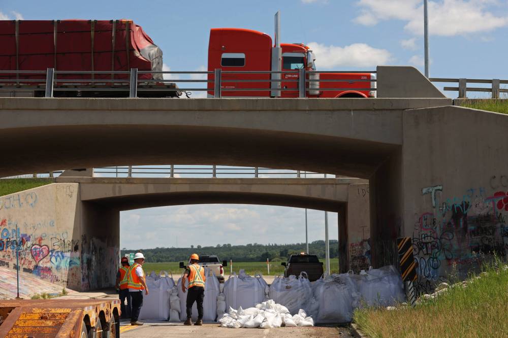
Workers install super sandbags to block off access to Grand Valley Road at the Trans-Canada Highway overpass on Wednesday as part of flood preparations. (Tim Smith/The Brandon Sun)
“The province continues to respond and has started recovery efforts throughout the Parkland region and western Manitoba,” the province said.
“Provincial staff continue to repair damaged highways and other infrastructure, restore access to affected areas and assess impacts from recent flooding.”
The provincial government said there is no “significant precipitation forecast” over the next several days.
Environment Canada, however, says there is a 60 per cent chance of showers today, including a risk of thunderstorms in the late afternoon, and a 30 per cent chance of showers on both Friday and Saturday.
The province’s bulletin also said that peak water levels are expected to hit Portage la Prairie on July 16, and that the Portage diversion is in operation to manage flows on the river downstream.
» alambert@brandonsun.com