Snow, rain won’t worsen flood threat, officials say
Advertisement
Read this article for free:
or
Already have an account? Log in here »
We need your support!
Local journalism needs your support!
As we navigate through unprecedented times, our journalists are working harder than ever to bring you the latest local updates to keep you safe and informed.
Now, more than ever, we need your support.
Starting at $15.99 plus taxes every four weeks you can access your Brandon Sun online and full access to all content as it appears on our website.
Subscribe Nowor call circulation directly at (204) 727-0527.
Your pledge helps to ensure we provide the news that matters most to your community!
To continue reading, please subscribe:
Add Brandon Sun access to your Free Press subscription for only an additional
$1 for the first 4 weeks*
*Your next subscription payment will increase by $1.00 and you will be charged $20.00 plus GST for four weeks. After four weeks, your payment will increase to $24.00 plus GST every four weeks.
Read unlimited articles for free today:
or
Already have an account? Log in here »
Hey there, time traveller!
This article was published 01/05/2011 (5301 days ago), so information in it may no longer be current.
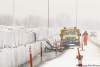
WINNIPEG — This weekend’s barrage of rain and snow will prolong the spring flood but not cause significant new problems, provincial flood officials said this afternoon.
The storm is not expected to cause significant water level rises on the Assiniboine River, said provincial flood fighters. And while the main stem of the Red River may experience a more prolonged crest and slower recession, there will not be an increase in peak water levels. The peak will pass through Winnipeg from Monday to Thursday.
In the Souris River basin, the storm could result in localized overland flooding in the area.
In the Dauphin Lake Basin, some streams affected by high-elevation snowfall will see another peak, with water levels expected to stay within stream banks depending on how fast the snow melts.
Water levels in Brandon are now the second highest in recorded history, surpassed by 1923 peak water levels. Flood protection dikes in the area are at 1,184 feet, well above the upper range of the forecasted peak at 1,181.2 feet.
Flood warnings have been issued for the Souris River from Melita and all downstream reaches; the Assiniboine River downstream of Shellmouth Bridge to Portage la Prairie; the Pipestone Creek, all reaches; Oak Lake and Plum Lakes; and Plum Creek to the Souris River (including the town of Souris).
Flood watches are in place for the Assiniboine River downstream of Portage la Prairie and the Qu’Appelle River in the St-Lazare area.
Overland flooding is expected in areas that received significant precipitation.
Advertisement Advertise With Us