RM of Miniota declares emergency
Advertisement
Read this article for free:
or
Already have an account? Log in here »
We need your support!
Local journalism needs your support!
As we navigate through unprecedented times, our journalists are working harder than ever to bring you the latest local updates to keep you safe and informed.
Now, more than ever, we need your support.
Starting at $15.99 plus taxes every four weeks you can access your Brandon Sun online and full access to all content as it appears on our website.
Subscribe Nowor call circulation directly at (204) 727-0527.
Your pledge helps to ensure we provide the news that matters most to your community!
To continue reading, please subscribe:
Add Brandon Sun access to your Free Press subscription for only an additional
$1 for the first 4 weeks*
*Your next subscription payment will increase by $1.00 and you will be charged $20.00 plus GST for four weeks. After four weeks, your payment will increase to $24.00 plus GST every four weeks.
Read unlimited articles for free today:
or
Already have an account? Log in here »
Hey there, time traveller!
This article was published 06/05/2011 (5451 days ago), so information in it may no longer be current.
The RM of Miniota declared a state of emergency on Thursday afternoon, as a record-breaking Assiniboine River put two households on an evacuation warning.
"It’s the first time they’ve ever had problems there," said Miniota deputy reeve Lyle Salmon.
Salmon declined to name the families affected.
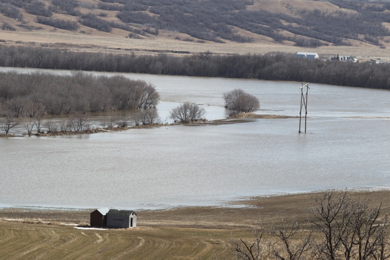
Overland flooding and high water flows on the Assiniboine River of 23,800 cubic feet per second were also cited as factors in the call for a state of emergency, as road access issues mount.
"Flooding has been experienced in the basement of one home," Salmon said. "PR 457 has been closed and (Manitoba Infrastructure and Transportation officials) are monitoring Highway 83."
The Highway 83 bridge over the Assiniboine River is now a concern, because it was built to withstand 16,000 cfs, not the much higher flows now hitting the bridge, Salmon said.
"They are monitoring that every hour," Salmon said. "The water is splashing up against the bridge. Water could go over it."
Manitoba Water Stewardship projections report the Assiniboine River has risen 8.5 centimetres to 380.13 metres above sea level. Water is expected to crest there between Saturday and Monday at a range of 380.24 metres above sea level to 380.45 metres — levels that will threaten the highest ever recorded level from 1923.
If Highway 83 has to close, it will join the list of 100 provincial roads affected by flooding, with 67 of them closed to traffic, said Manitoba Infrastructure and Transportation Minister Steve Ashton.
"That’s going to be one of the long-term impacts of this flood," Ashton said in yesterday’s flood briefing. "It may not drain any time soon in some areas."
The Shellmouth Reservoir is feeding that crest as water outflows increased to 10,700 cfs, including an increased spillway flow of 9,190 cfs.
"We chose to go to 11,000 because inflows are still exceeding outflows," said Steve Topping, Manitoba Water Stewardship’s executive director for regulatory and operational services.
"We feel the target inflow will start to match outflow and the reservoir will start declining in upcoming days."
The reservoir is 1.66 metres above flood stage at a level of 430.97 metres above sea level.
"It’s close to reaching the peak elevation on the reservoir and we really need to get some storage in the reservoir for potential rainfall events during the growing season," Topping said. "We want to take the reservoir down to create a buffer in the event of rainfall in the upper part of the Assiniboine basin."
Crest projections on the Assiniboine River at Brandon have been revised, with a crest now expected between May 12-14, one day later than yesterday’s report.
Flows are also expected to be higher, increasing by about 1,000 cfs to 27,500 cfs.
The water level projection remains at between 359.664 metres above sea level, a fraction of a centimetre over the record 1923 level, or as high as 360.03 metres.
Yesterday, the level was 359.56 metres above sea level, 10 centimetres below the 1923 record.
Souris River levels have stabilized in Manitoba. At Wawanesa, the river is at 352.27 metres above sea level at 13,750 cfs. However, the Alameda reservoir at Oxbow, Sask., rose 23.1 centimetres over the past 24 hours, and 8.63 metres this spring.
Water level at the Rafferty reservoir at Estevan, Sask., has also consistently increased, rising another 10.67 centimetres overnight.
Brandon Mayor Shari Decter Hirst told the Brandon Chamber of Commerce yesterday that the city will join the Assiniboine Hills Conservation District to work with neighbouring municipalities on watershed issues.
"The city works co-operatively with the communities that surround us," Decter Hirst said. "That’s critical because the river runs through us and there’s drainage issues as well. There’s no sense to not be at that table."
That group includes Souris River communities south of Brandon, such as Souris and Wawanesa.
The Brandon Flood Liaison Office will close today because of a lack of call volumes. Provincial flood information will still be available by calling 729-1220, but the call will be patched through to another office.
Related Articles
Grand Valley Road residents worry as water nears houses
Advertisement Advertise With Us
Advertisement Advertise With Us