Radar satellite launched by India and NASA will track miniscule changes to Earth’s land and ice
Advertisement
Read this article for free:
or
Already have an account? Log in here »
We need your support!
Local journalism needs your support!
As we navigate through unprecedented times, our journalists are working harder than ever to bring you the latest local updates to keep you safe and informed.
Now, more than ever, we need your support.
Starting at $15.99 plus taxes every four weeks you can access your Brandon Sun online and full access to all content as it appears on our website.
Subscribe Nowor call circulation directly at (204) 727-0527.
Your pledge helps to ensure we provide the news that matters most to your community!
To continue reading, please subscribe:
Add Brandon Sun access to your Free Press subscription for only an additional
$1 for the first 4 weeks*
*Your next subscription payment will increase by $1.00 and you will be charged $20.00 plus GST for four weeks. After four weeks, your payment will increase to $24.00 plus GST every four weeks.
Read unlimited articles for free today:
or
Already have an account? Log in here »
Hey there, time traveller!
This article was published 30/07/2025 (269 days ago), so information in it may no longer be current.
CAPE CANAVERAL, Fla. (AP) — NASA and India paired up to launch an Earth-mapping satellite on Wednesday capable of tracking even the slightest shifts in land and ice.
The $1.3 billion mission will help forecasters and first responders stay one step ahead of floods, landslides, volcanic eruptions and other disasters, according to scientists.
Rocketing to orbit from India, the satellite will survey virtually all of Earth’s terrain multiple times. Its two radars — one from the U.S. and the other from India — will operate day and night, peering through clouds, rain and foliage to collect troves of data in extraordinary detail.
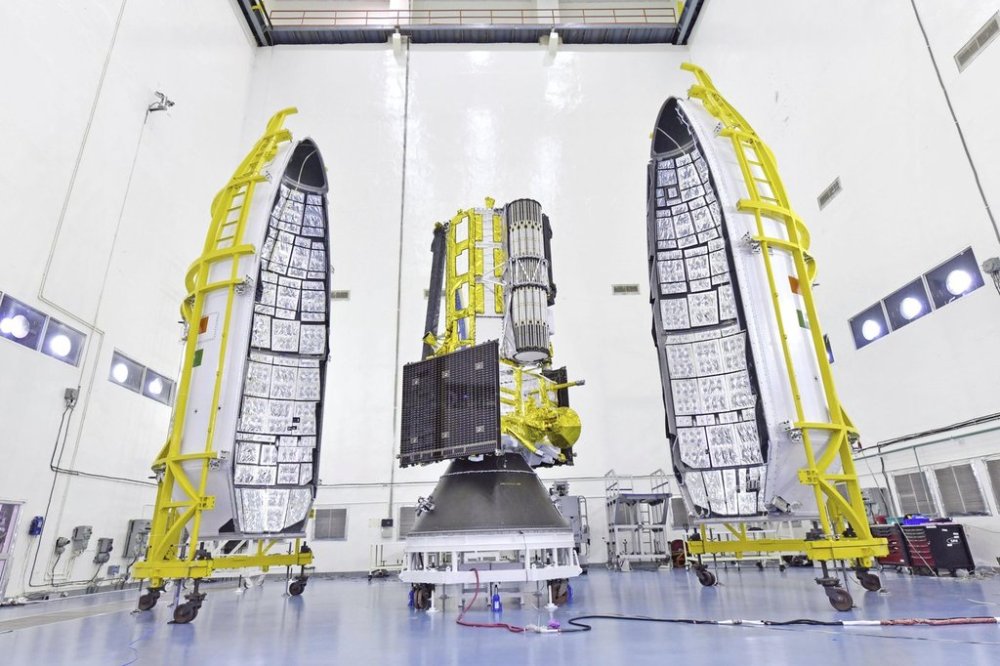
Microwave signals beamed down to Earth from the dual radars will bounce back up to the satellite’s super-sized antenna reflector perched at the end of a boom like a beach umbrella. Scientists will compare the incoming and outgoing signals as the spacecraft passes over the same locations twice every 12 days, teasing out changes as small as a fraction of an inch (1 centimeter).
It’s “a first-of-its-kind, jewel radar satellite that will change the way we study our home planet and better predict a natural disaster before it strikes,” NASA’s science mission chief Nicky Fox said ahead of liftoff.
Fox led a small NASA delegation to India for the launch.
It will take a full week to extend the satellite’s 30-foot (9-meter) boom and open the 39-foot-in-diameter (12-meter) drum-shaped reflector made of gold-plated wire mesh. Science operations should begin by the end of October.
Among the satellite’s most pressing measurements: melting glaciers and polar ice sheets; shifting groundwater supplies; motion and stress of land surfaces prompting landslides and earthquakes; and forest and wetland disruptions boosting carbon dioxide and methane emissions.
NASA is contributing $1.2 billion to the three-year mission; it supplied the low-frequency radar and reflector. The Indian Space Research Organization’s $91 million share includes the higher-frequency radar and main satellite structure, as well as the launch from a barrier island in the Bay of Bengal. It’s the biggest space collaboration between the two countries.
The satellite called NISAR — short for NASA-ISRO Synthetic Aperture Radar — will operate from a near-polar-circling orbit 464 miles (747 kilometers) high. It will join dozens of Earth observation missions already in operation by the U.S. and India.
___
The Associated Press Health and Science Department receives support from the Howard Hughes Medical Institute’s Department of Science Education and the Robert Wood Johnson Foundation. The AP is solely responsible for all content.