Lake Wahtopanah by the numbers
Advertisement
Read this article for free:
or
Already have an account? Log in here »
We need your support!
Local journalism needs your support!
As we navigate through unprecedented times, our journalists are working harder than ever to bring you the latest local updates to keep you safe and informed.
Now, more than ever, we need your support.
Starting at $15.99 plus taxes every four weeks you can access your Brandon Sun online and full access to all content as it appears on our website.
Subscribe Nowor call circulation directly at (204) 727-0527.
Your pledge helps to ensure we provide the news that matters most to your community!
To continue reading, please subscribe:
Add Brandon Sun access to your Free Press subscription for only an additional
$1 for the first 4 weeks*
- Enjoy unlimited reading on brandonsun.com
- Read the Brandon Sun E-Edition, our digital replica newspaper
*Your next Free Press subscription payment will increase by $1.00 and you will be charged $20.95 plus GST for four weeks. After four weeks, your payment will increase to $24.95 plus GST every four weeks.
Read unlimited articles for free today:
or
Already have an account? Log in here »
Hey there, time traveller!
This article was published 08/07/2020 (2154 days ago), so information in it may no longer be current.
The provincial government has said the water level in Lake Wahtopanah in Rivers has recently reached record highs.
Infrastructure Minister Ron Schuler called the recent rainfall a one-in-a-1,000-year event, but how do you quantify that?
To put things in perspective, here are some of the key numbers when it comes to the lake and its dam.
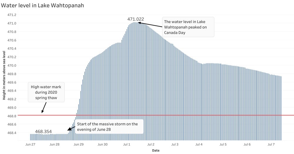
According to data obtained from the Government of Canada online hydrometric data, the water level in the lake was approximately 469.7 metres above sea level. At the water level’s peak on Canada Day, the lake had swollen to 471.022 metres above sea level.
A spokesperson from Manitoba Infrastructure said the approximate normal water level in the lake is 468.4 metres above sea level, meaning the water still has to recede by more than a metre to return to normal.
When the water was at its height on Canada Day, 12,000 cubic feet per second of water was going through the spillway at the dam at Lake Wahtopanah. On Tuesday, it had gone down to 4,400 cubic feet per second. A different government spokesperson told the Sun earlier this week the regular flow through the spillway is 330 cubic feet per second.
All of this happened because 178 millimetres of rain fell on Rivers from 1 p.m. on June 28 through noon on July 1.
» The Brandon Sun