More rain to compound flood woes in Westman
Advertisement
Read this article for free:
or
Already have an account? Log in here »
We need your support!
Local journalism needs your support!
As we navigate through unprecedented times, our journalists are working harder than ever to bring you the latest local updates to keep you safe and informed.
Now, more than ever, we need your support.
Starting at $15.99 plus taxes every four weeks you can access your Brandon Sun online and full access to all content as it appears on our website.
Subscribe Nowor call circulation directly at (204) 727-0527.
Your pledge helps to ensure we provide the news that matters most to your community!
To continue reading, please subscribe:
Add Brandon Sun access to your Free Press subscription for only an additional
$1 for the first 4 weeks*
- Enjoy unlimited reading on brandonsun.com
- Read the Brandon Sun E-Edition, our digital replica newspaper
*Your next Free Press subscription payment will increase by $1.00 and you will be charged $20.95 plus GST for four weeks. After four weeks, your payment will increase to $24.95 plus GST every four weeks.
Read unlimited articles for free today:
or
Already have an account? Log in here »
Hey there, time traveller!
This article was published 18/05/2022 (1478 days ago), so information in it may no longer be current.
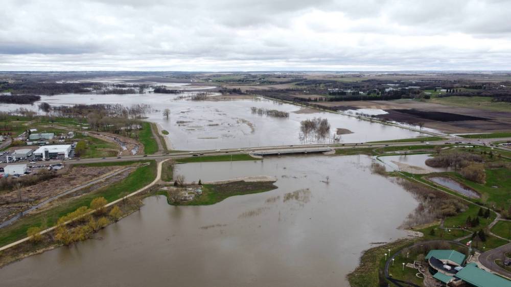
Westman’s flood fight is about to get a whole lot tougher.
A weather system is expected to drop up to 90 millimetres of rain on western and central Manitoba by Friday.
That rain won’t just affect already-swollen rivers like the Little Saskatchewan and Assiniboine, but also the Shellmouth Reservoir on the border of Saskatchewan and Manitoba that feeds into them.
Because of concerns the Shellmouth could reach capacity, the province will likely have to increase outflow from the reservoir into areas downstream.
When that happens, waterflows along the Assiniboine River in Brandon will increase by 14,000 to 16,000 cubic feet per second (396.4 to 453.1 cubic metres per second). As of 2 p.m. Wednesday, water was flowing at a rate of approximately 13,525.5 cubic feet per second (383 cubic metres per second).
The Assiniboine River in Brandon is expected to peak between Friday and Tuesday.
Along the Little Saskatchewan River, which is responsible for flooding in Minnedosa, the current water level and flow are the second-highest on record.
The worsening conditions are prompting concerns among provincial officials about the pressure being exerted on the dam in Minnedosa, said Johanu Botha, the head of Manitoba’s Emergency Measures Organization, in a media update Wednesday afternoon.
“There’s [talk] of removing logs to do that,” Botha said about relieving that pressure. According to Botha, Manitoba Infrastructure and the town are working together to determine the potential impacts of removing logs on water flow and the evacuation notices that may be needed as a result.
Infrastructure and Transportation Minister Doyle Piwniuk said his department and Minnedosa are in constant contact and working together to prepare for any eventuality.
The upcoming storm is expected to increase the flows near Minnedosa and Rivers by 1,000 to 2,000 cubic feet per second, according to Fisaha Unduche, the province’s executive director of hydrologic forecasting and water management. The water level at the dam at Lake Wahtopanah in Rivers could increase another 1.3 to 1.6 feet.
“Heavy rain is projected between 40 and 90 millimetres along the areas of Roblin, Dauphin, Portage, Dauphin, St. Lazare and the central part [of the province],” Unduche said.
“The Assiniboine River, Shellmouth basin could also be impacted by this. We issued an overland flood warning for this area [Tuesday] and all these … warnings remain in effect until Saturday.” The Shellmouth basin in Saskatchewan is expected to be impacted by this rain and may get 40 to 90 millimetres of a rain and snow mix for the next three days.
Because of the impact on the basin, provincial staff are currently working to determine how quickly areas downstream will feel the impact.
The Shellmouth Reservoir’s current water level is 1,399.8 feet above sea level, which Unduche said is the third-lowest level over the last 40 years. The outflow is 3,300 cubic feet of water per second, the highest controlled release since the dam was completed in 1970.
The province’s intent was to release more water to make space for additional precipitation so the outflow can be reduced later on for agricultural purposes. However, with the new precipitation forecast, the province now expects outflow to soar to between 7,020 to 11,000 cubic feet per second under that plan.
“Basically, that inflow is beyond the capacity of the reservoir, so we will be — depending on how much rain we expect — increasing outflow from the reservoir,” Unduche said. “Again, the intent is to have more storage for June/July rain.”
Southern and central Manitoba water basins have received approximately 150 per cent of the normal precipitation amounts for this time of year since April 1, he said.
“Recently, rain patterns have shifted to impact western Manitoba and the Parkland region,” Unduche said.
Thankfully, Unduche said, most rivers in southern Manitoba have already seen their water levels peak.
“This flood fight has already gone on much longer than anyone would have liked,” Botha said. “We’re certainly in it until it is finished. Over the last week, we’ve really seen the response activity expand from the Red River Valley and Interlake into the west. All of southern Manitoba is in the fight at the moment.”
The Emergency Measures Organization has received requests for thousands of pieces of flood-fighting equipment as 40 municipalities and 10 Northern Affairs communities have active states of emergency due to the flooding situation, Botha said. The province would be making webinars available with instructions for people and businesses needing to apply for disaster financial assistance soon.
“I just want to remind Manitobans that heavy rain can lead to dangerous situations, including flash flooding and extreme overland flooding,” Botha said. “People in affected areas should take actions to protect their families and their homes and should be prepared to evacuate if needed.”
Residents, especially those in western Manitoba, should avoid crossing bodies of water of any depth and try to avoid valleys, low-lying areas, waterways and flooded areas.
» cslark@brandonsun.com
» Twitter: @ColinSlark