North Dakota braces for possible spring flood
Advertisement
Read this article for free:
or
Already have an account? Log in here »
We need your support!
Local journalism needs your support!
As we navigate through unprecedented times, our journalists are working harder than ever to bring you the latest local updates to keep you safe and informed.
Now, more than ever, we need your support.
Starting at $15.99 plus taxes every four weeks you can access your Brandon Sun online and full access to all content as it appears on our website.
Subscribe Nowor call circulation directly at (204) 727-0527.
Your pledge helps to ensure we provide the news that matters most to your community!
To continue reading, please subscribe:
Add Brandon Sun access to your Free Press subscription for only an additional
$1 for the first 4 weeks*
*Your next subscription payment will increase by $1.00 and you will be charged $20.00 plus GST for four weeks. After four weeks, your payment will increase to $24.00 plus GST every four weeks.
Read unlimited articles for free today:
or
Already have an account? Log in here »
Hey there, time traveller!
This article was published 11/04/2023 (1113 days ago), so information in it may no longer be current.
Warmer weather and melting snow have prompted a flood warning for the Red River north of Fargo, as Winnipeggers with flood-prone properties stocked up on sandbags Monday.
“It could be a pretty good-sized flood,” Fargo Mayor Tim Mahoney said at a news conference Monday.
A Manitoba flood expert doesn’t expect the forecast for this province has changed from last month.
“There will be a major flood on the main stem of the Red — there’s no question it’s going to spill its banks,” said Jay Doering, a hydrology expert and civil engineering professor.
“But, at this point in time, I don’t see this being a challenge for either ring-dike communities or Highway 75.”
On March 22, Manitoba’s flood forecast warned that major dumps of snow in the Dakotas and Minnesota could spell trouble along the Red River north of the border, depending on how fast it melts and how much more precipitation fell.
Doering, the University of Manitoba graduate studies professor emeritus whose expertise was called on by the province during 1997’s “Flood of the Century” and for the expansion of the Manitoba Floodway, said the 10-day weather forecast calling for warmer and then cooler temperatures with little rain bodes well in Manitoba.
The U.S. National Weather Service forecast moderate flooding beginning late Thursday night, owing to above-freezing temperatures melting large amounts of snow in North Dakota.
The anticipated melting will result in increased flows of water, and may result in rapidly rising rivers, including the Red, it said.
Fargo, West Fargo and Cass County held a joint news conference at Fargo city hall to update the public on the upcoming flood efforts.
The flood along the Red north of Fargo could be “one of the Top 10” of all time, Mahoney said.
The U.S. weather service said the situation all depends on how high temperatures get over the next several days, and if there’s significantly more rainfall than the limited amount expected later this week.
“We have to be prepared,” he said, urging North Dakotans to volunteer their time and effort to fill sandbags.
“We can hope and pray that we have just a nice soft spring and it’s wonderful and that we barely get any flooding, but bear in mind that we are going to have a flood fight — it just might not be as high as earlier predicted,” Mahoney said at Monday’s livestreamed event.
“If we make too many sandbags, we can always put them in storage and keep them.”
Unless there’s some major precipitation or hot spell, don’t expect Manitoba’s flood forecast to change, said Doering, who has been waiting for North Dakota’s melt to begin.
“It usually takes 10 to 14 days to make it to the border and then another five to seven days to make it into Winnipeg,” he said. “You’re sort of two to three weeks out — that’s going to put us at the end of the month.”
The forecast for the next 10 days calls for six to nine millimetres of rain, with temperatures in the low teens Tuesday, up to 16 C Wednesday and then dropping to single digits for a few days.
“If we get a ton of rain or if it gets really, really hot, it changes things,” Doering said Monday, adding the province’s late-March forecast moved from a “moderate” to a “major” flood risk, which means the floodway will be in service.
The Red is likely to crest in the city in late April and flood the riverwalk at The Forks. The province’s March 22 flood forecast said with favourable weather conditions, river levels would be at 17.5 feet at James Avenue; unfavourable weather would see it rise to just over 19.5 feet James, nowhere near as high as in 1997, when it reached 24.5 feet.
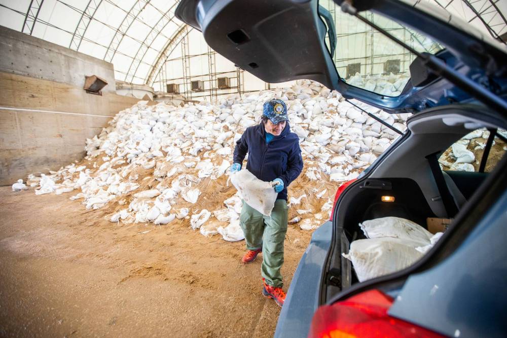
Some Winnipeg homeowners stopped in at the city’s east district public works yard (960 Thomas Ave.) to pick up free sandbags to shore up their properties — from the melting snow, not the rising Red River.
The Windsor Park home Irv Hildebrand and his wife share held up well for about 40 spring melts, he said, but two big cracks in the foundation led to a flooded basement last year.
“It was that huge rain in the spring, when the ground was all frozen,” he said. “It couldn’t run anywhere, it was just horrible.”
They had been away from home at the time, and when they returned, the water was at waist height.
Hildebrand said he’s trying to get a contractor to fix the problem spots — but can’t get him in to work until June.
“That’s the problem,” he said while loading his sedan with about 15 sandbags.
Jake Sabillo, 48, said his yard in Garden City is a little higher than the garage, a problem when it warms up.
“When the snow melts, it goes right inside,” said Sabillo.
He and his family moved to the property last year and experienced a minor flood of a few centimetres.
“But I had just put a carpet down… then the snow melted,” he said with a laugh.
» Winnipeg Free Press