Province issues flood warning for Assiniboine River
Advertisement
Read this article for free:
or
Already have an account? Log in here »
We need your support!
Local journalism needs your support!
As we navigate through unprecedented times, our journalists are working harder than ever to bring you the latest local updates to keep you safe and informed.
Now, more than ever, we need your support.
Starting at $15.99 plus taxes every four weeks you can access your Brandon Sun online and full access to all content as it appears on our website.
Subscribe Nowor call circulation directly at (204) 727-0527.
Your pledge helps to ensure we provide the news that matters most to your community!
To continue reading, please subscribe:
Add Brandon Sun access to your Free Press subscription for only an additional
$1 for the first 4 weeks*
- Enjoy unlimited reading on brandonsun.com
- Read the Brandon Sun E-Edition, our digital replica newspaper
*Your next Free Press subscription payment will increase by $1.00 and you will be charged $20.95 plus GST for four weeks. After four weeks, your payment will increase to $24.95 plus GST every four weeks.
Read unlimited articles for free today:
or
Already have an account? Log in here »
Hey there, time traveller!
This article was published 13/04/2024 (784 days ago), so information in it may no longer be current.
Assinboine River from the Shellmouth Dam to Brandon was put under a flood warning on Friday after recent snow melt contributed to high-flowing rivers and tributaries, Manitoba Transportation and Infrastructure said in a media release.
“A flood warning has been issued for these areas as the rising water levels could impact low-lying areas,” the release said. “The Assiniboine River is expected to be within the banks in the third week of April.”
On top of that, the outflow from the Shellmouth Dam is being increased from 1,000 to 3,000 cubic feet per second to accommodate increased water flow from Saskatchewan. The release said the inflow to the reservoir is currently at 6,355 cubic feet per second.
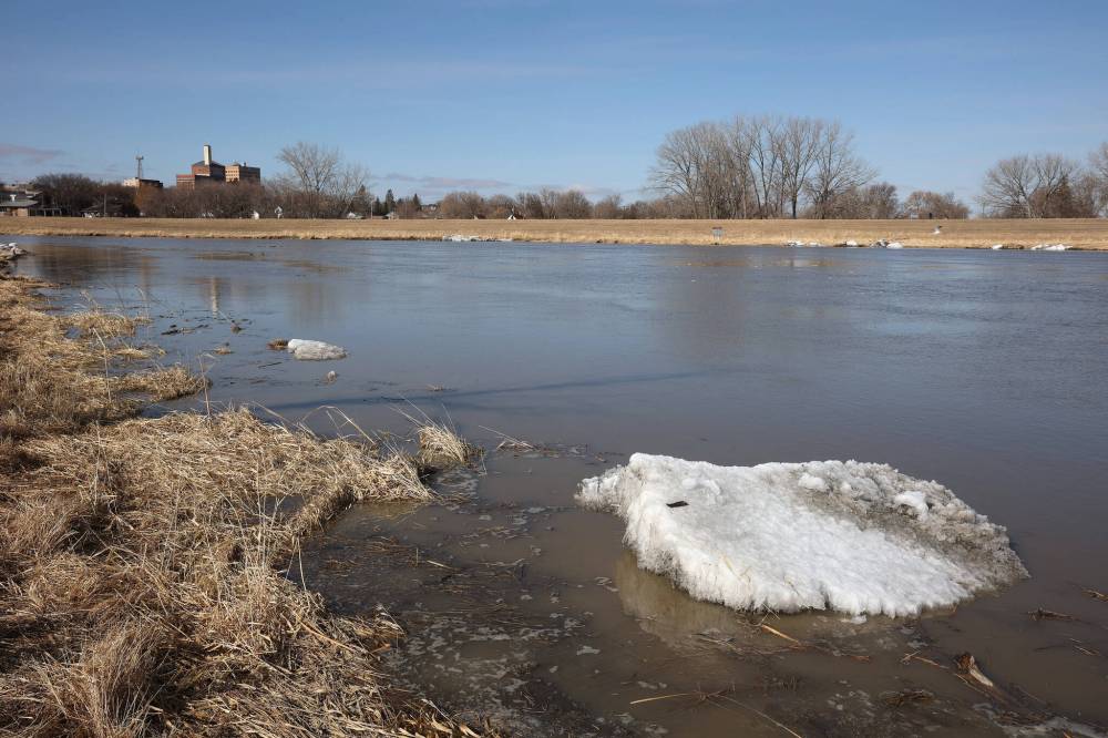
Ice clings to the shore of the swollen Assiniboine River in Brandon. The province issued a flood warning on Friday but the city's emergency co-ordinator says residents needn't worry, just monitor the situation near their properties. (File)
In the middle of next week, a mix of rain and snow is expected to bring 40 millimetres of precipitation to Manitoba, Saskatchewan and the United States portions of the Red River’s basin.
The province said it is not expecting the weather to significantly impact most parts of southern and central Manitoba as most rivers and streams have already peaked in terms of water level, but updated forecasts would be issued once more information is known.
The Portage Diversion was briefly operated Friday to regulate water levels on the Assiniboine River east of Portage la Prairie.
Reached by phone Friday afternoon, Brandon emergency co-ordinator Tobin Praznik said the city was notified in advance of the increase in flow by the province.
“As much as it’s dry here in Brandon and we don’t have a lot of snow in our area, we still have to be monitoring the situation upstream with the Shellmouth Dam, all the tributaries and everything coming through,” Praznik said.
Extra water from the dam, he said, won’t arrive in Brandon for another week or so.
Environment Canada’s seven-day forecast as of Friday projected a 30 per cent chance of rain today as well as rain on Tuesday, Wednesday and Thursday next week.
Praznik said residents shouldn’t worry but should continue to monitor the situation. If the situation changes, the city will alert residents through its social media pages.
“At this point, just recognize this is normal spring runoff and the river is quite dangerous with how fast it’s moving,” he said. “Stay away from that area, including with pets. Don’t let them run free because it is quite dangerous at this time until things settle down.”
The province’s advice to Manitobans is to stay off ice surfaces, which are weakening, and to be cautious around water systems.
Areas in Brandon potentially affected by rising water levels as well as the breakup of ice on the river include Dinsdale and Queen Elizabeth parks, low-lying areas on 18th Street and other areas around the Assiniboine.
Manitoba’s online river conditions map said Friday that the water level of the Assiniboine was about 1,175 feet above sea level and flowing at a rate of 8,579 cubic feet per second.
By comparison, the 2011 flood saw the Assiniboine River in Brandon rise higher than 1,180 feet above sea level. Brandon’s dike system built after that flood sits at 1,186 feet above sea level.
» cslark@brandonsun.com
» X: @ColinSlark