Researchers confirm six tornadoes
Advertisement
Read this article for free:
or
Already have an account? Log in here »
We need your support!
Local journalism needs your support!
As we navigate through unprecedented times, our journalists are working harder than ever to bring you the latest local updates to keep you safe and informed.
Now, more than ever, we need your support.
Starting at $15.99 plus taxes every four weeks you can access your Brandon Sun online and full access to all content as it appears on our website.
Subscribe Nowor call circulation directly at (204) 727-0527.
Your pledge helps to ensure we provide the news that matters most to your community!
To continue reading, please subscribe:
Add Brandon Sun access to your Free Press subscription for only an additional
$1 for the first 4 weeks*
*Your next subscription payment will increase by $1.00 and you will be charged $20.00 plus GST for four weeks. After four weeks, your payment will increase to $24.00 plus GST every four weeks.
Read unlimited articles for free today:
or
Already have an account? Log in here »
Hey there, time traveller!
This article was published 20/06/2024 (671 days ago), so information in it may no longer be current.
A storm that swept through eastern Saskatchewan and Westman on Wednesday last week spawned six tornadoes, researchers from the Northern Tornadoes Project have determined.
One tornado touched down near Saltcoats, Sask., two near Rivers, one in Spruce Woods Provincial Park and the final two near Saint Alphonse, according to a blog post from the project.
There was also a downburst, a strong downward wind from above, recorded after the Spruce Woods tornado.
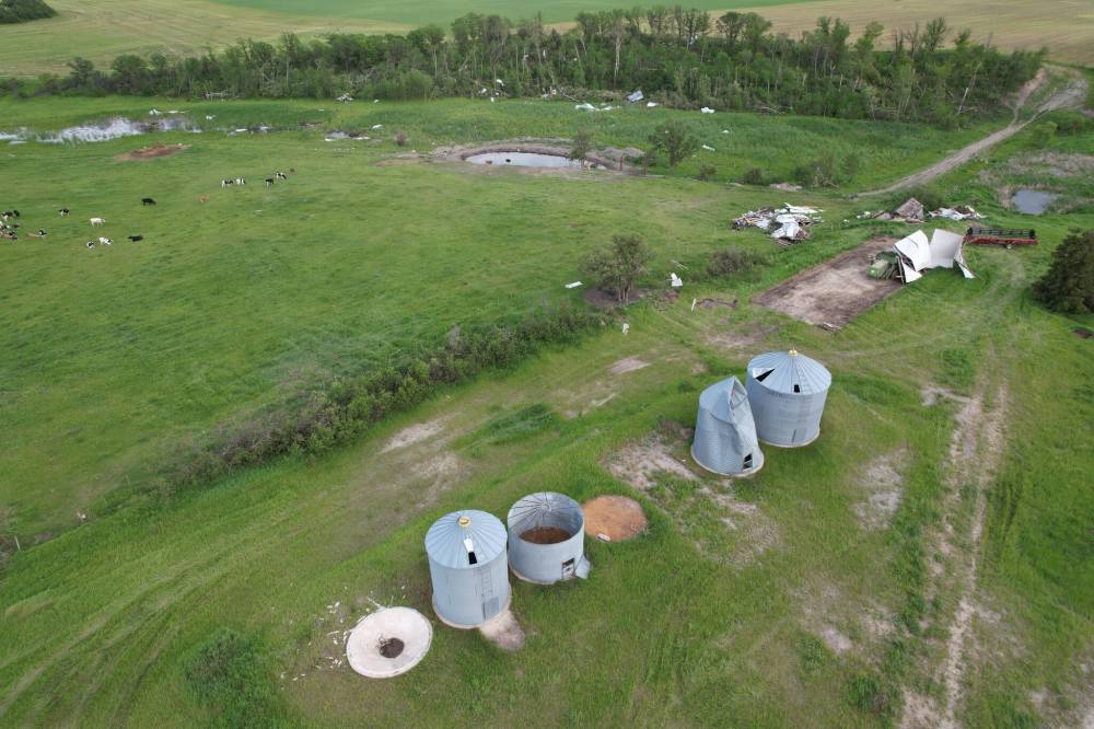
Farm buildings, grain silos and trees were damaged by a tornado near Saint Alphonse and Swan Lake First Nation on June 12. (Northern Tornadoes Project)
Four of the six tornadoes have been categorized as zeroes, the lowest point on the Enhanced Fujita (EF) scale, while the Spruce Woods tornado and the Saint Alphonse tornado, which damaged powwow grounds at Swan Lake First Nation, have been assigned ratings of EF1.
Based out of Western University in London, Ont., the project dispatches teams of researchers and students across Canada to study tornadoes and the damage they do so they can be better understood and predicted.
The tornado project’s blog post noted that these were the first confirmed tornadoes for both Saskatchewan and Manitoba this season, “a somewhat late start in those provinces.”
Reached by phone, the project’s executive director, David Sills, said that storms or weather systems creating multiple tornadoes like what happened last week is fairly common.
“Any storms that pop up in that region may have the potential to produce tornadoes,” Sills said. “Like we saw on June 12, it wasn’t just one storm. There were a number of storms that developed a rotation and were potential tornadoes producers.”
Just the day after, Sills said a system that hit Ontario and Quebec produced up to five tornadoes that the project is investigating.
To create a thunderstorm, Sills said you need lots of low-level moisture and instability in the atmosphere coupled with something generating lift so that clouds start to form.
Severe thunderstorms happen when wind shear is generated in the atmosphere, with the changes in wind strength and direction across different heights producing the ingredients needed for a tornado-producing storm.
One of the storms that hit Westman last week was a supercell, a long-lasting, highly organized storm capable of producing stronger tornadoes.
“It’s still being researches how exactly they produce tornadoes, but we do know that it’s a combination of a really strong updraft, the thunderstorm and rotation below the storm stretching that vortex near the ground into the vertical, really accelerating the rotation,” he said.
A difference between tornadoes and a downburst, one of which occurred in Spruce Woods, is that a tornado creates a long, narrow path of damage while a downburst has horizontal height and width that are roughly the same.
Sometimes a downburst becomes a tornado, but in last week’s cast, a tornado morphed into a downburst.
Ultimately, the tornadoes last week were low on the EF scale. Sills said that was surprising, because the radar signatures project staff were monitoring in real time suggested that major damage could have been done.
A two-person team from Winnipeg was dispatched to review the damage done in Saskatchewan and Westman, finding no evidence that any animals or people were hurt.
“It was mostly just damaged trees, but there were a couple of sheds that got obliterated and one farm outbuilding with construction on the weak side,” Sills said.
There were also a couple of grain bins that got dented or moved from their original location, along with the damage to the powwow arbour.
The tornado that damaged the powwow arbour at Swan Lake was the most powerful recorded from among the six, reaching wind speeds of up to 150 kilometres an hour and leaving a trail 19 kilometres long and as wide as 1.05 kilometres.
Two of the tornadoes were rated EF0 by default, meaning that the project received reliable information from storm chasers and residents that they happened, but didn’t hit anything that could be used to officially rank them on the scale.
If anyone has information on a tornado in progress, Sills asks that they reach out to Environment Canada first so that a warning can be issued. After that, though, the project is happy to receive photos, videos and reports by email to ntp@uwo.ca or through its website at uwo.ca/ntp/report.html.
With work on the June 12 storm complete, Sills said data is being reviewed from a storm that originated in Montana on June 15 and went northwards through North Dakota before ending just west of Winnipeg on June 16.
“There were a lot of big wind gusts with that, and there’s also some potential tornadoes that occurred along there,” he said.
Despite the bad weather over the past week, this June has not been as wet so far as June 2023 was in Brandon.
Last year, Environment and Climate Change Canada’s station in Brandon recorded 132.6 millimetres of rain in June. That includes the whopping 44.6 millimetres of rain that fell on June 8, 2023 alone.
Through the first 18 days of June 2024, 65.4 millimetres of rain have fallen. The heaviest rain came on June 17, with 24.4 millimetres.
It has also been cooler so far this June compared to last June. The average daily mean temperature in June 2023 was 19.8 C, compared to 14.9 C this year.
The most powerful tornado recorded by the project this year was an EF2 that touched down near Landings Lake, Ont.
Since the project launched in 2017, the most powerful tornadoes it has recorded in Manitoba have been an EF4 tornado south of Alonsa in 2018 and an EF3 tornado south of Virden in 2020.
» cslark@brandonsun.com
» X: @ColinSlark