Alberta clippers sweep into Westman
Advertisement
Read this article for free:
or
Already have an account? Log in here »
We need your support!
Local journalism needs your support!
As we navigate through unprecedented times, our journalists are working harder than ever to bring you the latest local updates to keep you safe and informed.
Now, more than ever, we need your support.
Starting at $15.99 plus taxes every four weeks you can access your Brandon Sun online and full access to all content as it appears on our website.
Subscribe Nowor call circulation directly at (204) 727-0527.
Your pledge helps to ensure we provide the news that matters most to your community!
To continue reading, please subscribe:
Add Brandon Sun access to your Free Press subscription for only an additional
$1 for the first 4 weeks*
*Your next subscription payment will increase by $1.00 and you will be charged $20.00 plus GST for four weeks. After four weeks, your payment will increase to $24.00 plus GST every four weeks.
Read unlimited articles for free today:
or
Already have an account? Log in here »
An Alberta clipper rolled through southwestern Manitoba on Monday — and a second one will dump as much as 20 centimetres of snow on the region today, according to Environment and Climate Change Canada.
People should expect road closures and prepare for delays as snow pelts the region all day Tuesday and into Wednesday morning, Natalie Hasell, warning preparedness meteorologist for ECCC, said Monday afternoon.
“Visibility could be reduced to near zero suddenly at times,” Hasell said. “And then with the passage of this system, we see colder temperatures come in the rest of the week.”
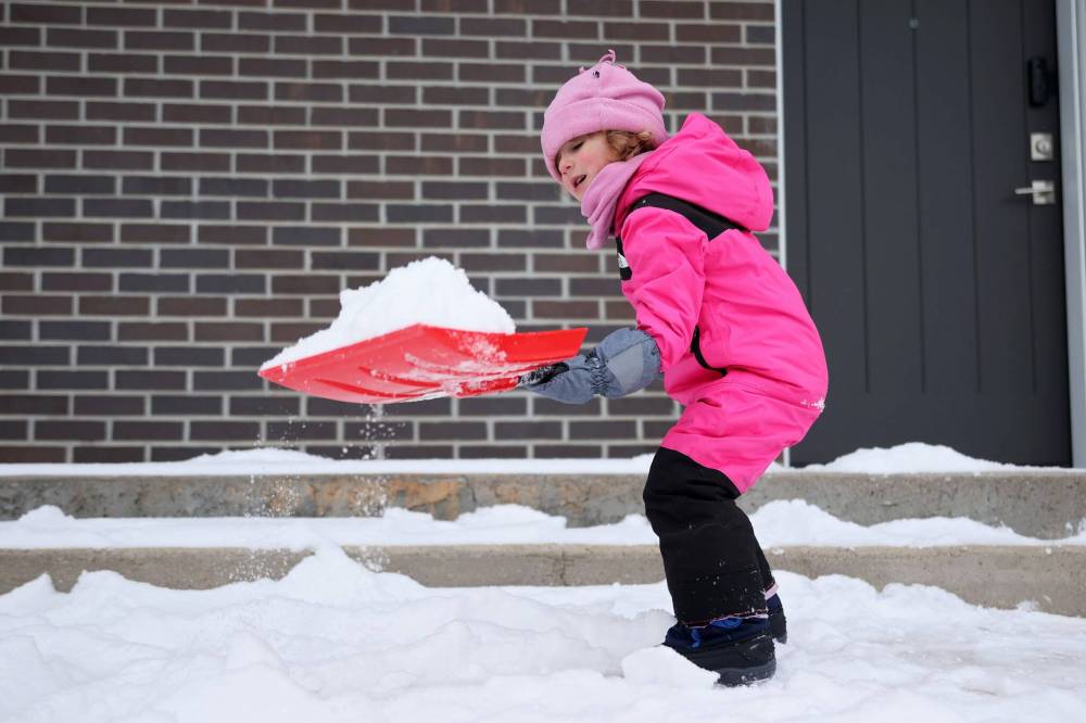
Three-year-old Aaliyah works hard to clear snow outside her family's home in Brandon on Monday afternoon after the Wheat City received fresh snow earlier in the day. According to Environment Canada, Brandon is under a winter storm watch for Tuesday. (Tim Smith/The Brandon Sun)
The Parkland region will see the most snow, with about 20 cm today, she said. Brandon will get closer to 15 cm. Some areas closer to the United States border could also see freezing rain.
A yellow storm watch — a new designation by ECCC describing hazardous weather that may cause damage, disruption or health impacts — was active over the course of the day on Monday.
The Trans-Canada was closed west of Virden for more than an hour and a half in the afternoon and highways across the region were covered in snow for much of the day.
Hasell said people can expect more road closures today.
She said people should check road conditions before going out and expect delays. They should also have an emergency kit in their vehicle and homes in case of an emergency or if they get stranded, she said.
“Having everything that you need in an emergency means that you can manage the emergency better,” Hasell said.
Emergency kits include a blanket, a change of clothes, a small shovel, food and something to keep you warm, like candles, she said.
“It won’t necessarily reduce the impact of the storm or the situation that puts you in an emergency, but you might be able to manage it better, mitigate the consequences better, if you are better prepared.”
The rest of the week will see below-average temperatures, Hasell said. A low of -29 C is expected Saturday.
“Our daytime temperatures are going to be colder than what we typically see at night starting on Friday,” she said.
“It won’t be warning conditions for cold, but it won’t be much better.”
While the coldest temperatures will be late this week and into the weekend, “below-normal temperatures” will last until Dec. 23, she said.
» alambert@brandonsun.com