Winter storm to wallop Westman
Advertisement
Read this article for free:
or
Already have an account? Log in here »
We need your support!
Local journalism needs your support!
As we navigate through unprecedented times, our journalists are working harder than ever to bring you the latest local updates to keep you safe and informed.
Now, more than ever, we need your support.
Starting at $15.99 plus taxes every four weeks you can access your Brandon Sun online and full access to all content as it appears on our website.
Subscribe Nowor call circulation directly at (204) 727-0527.
Your pledge helps to ensure we provide the news that matters most to your community!
To continue reading, please subscribe:
Add Brandon Sun access to your Free Press subscription for only an additional
$1 for the first 4 weeks*
- Enjoy unlimited reading on brandonsun.com
- Read the Brandon Sun E-Edition, our digital replica newspaper
*Your next Free Press subscription payment will increase by $1.00 and you will be charged $20.95 plus GST for four weeks. After four weeks, your payment will increase to $24.95 plus GST every four weeks.
Read unlimited articles for free today:
or
Already have an account? Log in here »
The Brandon region could be blanketed by up to 25 centimetres of snow by Thursday, while the Parkland region could see as much as 30 cm.
A storm system that formed in Montana pummelled Alberta on Tuesday with upwards of 40 cm of snow, before making its way to Saskatchewan and dumping up to 35 cm.
Westman was expected to be hit by the storm from Tuesday to Thursday, Environment and Climate Change Canada meteorologist Natalie Hasell said.
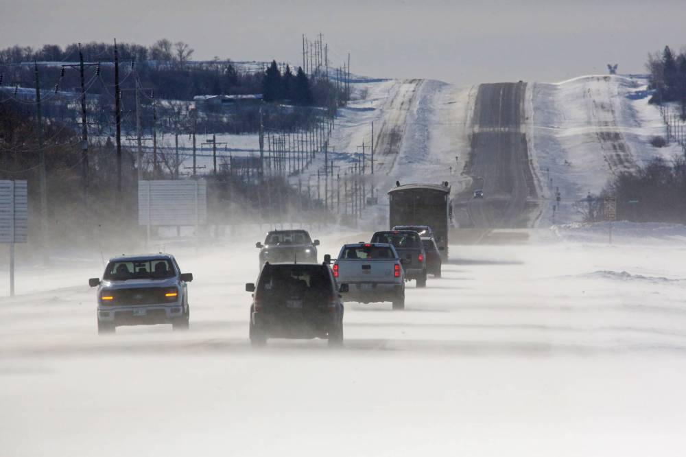
Hasell said the system will dump between 15 and 25 cm around Brandon.
“These amounts are not unusual for this type of snowstorm — however, it’s affecting all three Prairie provinces and quite a number of the states to our south,” she said.
“So, this is a large system with quite an extended reach.”
The worst conditions were expected to hit late Tuesday, with wind gusts as high as 70 kilometres an hour. The wind was expected to lessen today to about 30 km/h, but heavy snowfall could still create dangerous driving conditions, Hasell said.
“Important to check road conditions if you do have to travel. If you don’t have to travel, stay off the roads. It will be easier,” she said.
Southern Manitoba was under yellow warnings for snowfall and blowing snow on Tuesday afternoon, while western Saskatchewan was under an orange snowfall warning.
Additionally, freezing rain was expected to hit the region late Tuesday near the U.S. border and was expected to turn into snow later in the evening, Hasell said.
Hasell said while 15 to 25 cm is the best guide, there could be more snowfall away from ECCC’s forecast site.
Up until this system, there haven’t been many snowfalls this winter, with warmer temperatures also causing some melting to happen. Hasell said this week is “more of a return to winter.”
Hasell said the low-pressure centre of the storm is in the U.S., and American states are seeing similar conditions, with potentially worse freezing rain. Parts of northern Montana were under a blizzard warning on Tuesday.
In Edmonton, the storm caused crashes, cars were caught in snow drifts and some vehicles were unable to climb hills. Several flights out of the city’s airport were cancelled. Mounties in Saskatchewan reported multiple vehicles in ditches.
Hasell said people can expect another system to come into the region around Feb. 24, while colder temperatures stick around this week.
Lows of -22 C are expected over the weekend, while highs during the day will hit -15 C on Sunday, ECCC predictions show.
» alambert@brandonsun.com, with files from The Canadian Press