
Sioux Valley rallies to protect homes
Advertisement
Read this article for free:
or
Already have an account? Log in here »
We need your support!
Local journalism needs your support!
As we navigate through unprecedented times, our journalists are working harder than ever to bring you the latest local updates to keep you safe and informed.
Now, more than ever, we need your support.
Starting at $15.99 plus taxes every four weeks you can access your Brandon Sun online and full access to all content as it appears on our website.
Subscribe Nowor call circulation directly at (204) 727-0527.
Your pledge helps to ensure we provide the news that matters most to your community!
To continue reading, please subscribe:
Add Brandon Sun access to your Free Press subscription for only an additional
$1 for the first 4 weeks*
- Enjoy unlimited reading on brandonsun.com
- Read the Brandon Sun E-Edition, our digital replica newspaper
*Your next Free Press subscription payment will increase by $1.00 and you will be charged $20.95 plus GST for four weeks. After four weeks, your payment will increase to $24.95 plus GST every four weeks.
Read unlimited articles for free today:
or
Already have an account? Log in here »
It was “all hands on deck” in Sioux Valley Dakota Nation on Thursday as volunteers helped sandbag to protect homes, Chief Jennifer Bone said.
A few homes were evacuated because of the high water levels in the community, with a team from Peguis First Nation joining in to help. Dialysis patients were also being evacuated out of the community, she said.
“We’ve got some great efforts helping with sandbagging the areas within the flood zone,” Bone said on Thursday.
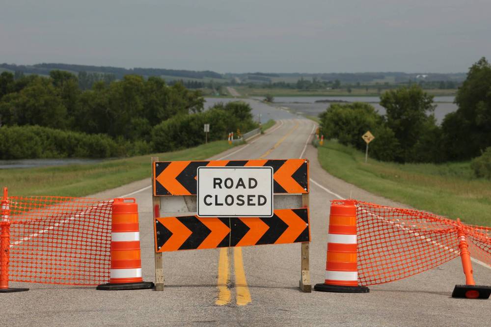
Barriers block access to Highway 21 at the Assiniboine River south of Sioux Valley Dakota Nation on Thursday after floodwaters from the rising Assiniboine covered the road just north of the river. (Tim Smith/The Brandon Sun)
“We have staff that have been helping out over the last few days, they’ve kind of been reassigned and working long hours.”
People were continuing to sandbag homes near the river and creek that flow through the community.
She also thanked Sioux Valley staff for their efforts.
“We have so many people that have come forward to help. I know we have staff that are cooking meals, providing lunch, providing supper, making sure that our crews that are working are staying hydrated and fed throughout their long days of work.”
Over in Brandon, Mayor Jeff Fawcett said the forecast currently remains the same as it was on Wednesday. Water levels were at 1,171.9 feet on Wednesday and were expected to rise seven to eight feet from Thursday until Monday, at which point it would stay near the peak level and then gradually recede.
The forecasted peak is slightly lower than the 1,185-foot peak during the 2014 flood, and the approximate 1,183-foot peak of the 2011 flood.
Fawcett, however, warned that each flood is different.
“While current forecasts suggest river levels may be similar to those seen in previous years, residents should understand that every high-water event is unique,” he said.
“So, the city’s response is based on current conditions, meaning some measures may mirror past actions, while others may be new or adapt to meet the specific needs of this event.”
Crews are still working at the Wheat City Golf Course and the Canada Packers Sports Complex.
Officials are also prepared to set up a reception centre at the Keystone Centre if evacuations become necessary, Fawcett said. The centre would help register evacuees, make arrangements for where they can stay and provide information.
Notices are being sent out to about 4,000 to 5,000 people near the river on what they should do if an evacuation happens.
Residents will be alerted of an evacuation order through the province’s alert ready system, local media, the city’s communication channels and door-to-door notification, Fawcett added.
He also warned people to stay away from the river and closed trails, as the areas can be more dangerous than they appear.
Virden Mayor Tina Williams said while there is flooding outside of town, those in the community should be fine as long as there isn’t significant rain.
“We have all the protections in place, and yeah, we just wait and see,” Williams said.
“Our state of emergency … we put it in place so that if something does go wrong with the water, we’re ready to move.”
Environment and Climate Change Canada meteorologist Julien Corriveau said it’s tough to say if there might be a storm this weekend in the region.
“We do have a chance of showers for Brandon, kind of Saturday night, Sunday night, so that kind of hints to me that there could be a risk of a storm this weekend,” Corriveau said.
Though a storm likely wouldn’t be widespread, he couldn’t rule anything out. Localized torrential downpours are possible.
The temperature from Saturday to Monday is expected to reach the mid-30s C range, with a humidex in the mid-40s C, he said.
“It’s really going to get hot, and also very humid.”
He said while the heat will evaporate water a little faster, it won’t eliminate flooding concerns. The evaporation, he said, will just add to the humidity.
The heat wave is happening because of a ridge of high pressure, which “tends to suppress thunderstorm development.”
“We would need some kind of trigger to really kick off any storms this weekend, so maybe a front moving through, or some kind of disturbance above ground, moving over,” Corriveau said.
The bottom line, Corriveau said, is storms that would have a large effect on flooding are unlikely.
He said during the heat wave, people should drink water, avoid time outside and try to seek air conditioning.
» alambert@brandonsun.com