Mandatory evacuations begin in RM of Riverdale
Brandon prepares for flooding, issues evacuation preparation notices
Advertisement
Read this article for free:
or
Already have an account? Log in here »
We need your support!
Local journalism needs your support!
As we navigate through unprecedented times, our journalists are working harder than ever to bring you the latest local updates to keep you safe and informed.
Now, more than ever, we need your support.
Starting at $15.99 plus taxes every four weeks you can access your Brandon Sun online and full access to all content as it appears on our website.
Subscribe Nowor call circulation directly at (204) 727-0527.
Your pledge helps to ensure we provide the news that matters most to your community!
To continue reading, please subscribe:
Add Brandon Sun access to your Free Press subscription for only an additional
$1 for the first 4 weeks*
*Your next subscription payment will increase by $1.00 and you will be charged $20.00 plus GST for four weeks. After four weeks, your payment will increase to $24.00 plus GST every four weeks.
Read unlimited articles for free today:
or
Already have an account? Log in here »
Hey there, time traveller!
This article was published 01/07/2020 (2121 days ago), so information in it may no longer be current.
Editor’s note: This is the latest information we have available on the potential for flooding along the Assiniboine and Little Saskatchewan rivers as of 11:33 p.m. on Wednesday night. We will be updating our website as we learn more.
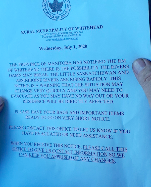
Manitoba Infrastructure has recommended the evacuation of people and livestock from about 30 to 40 properties along the Little Saskatchewan River downstream of the Rivers Dam in the rural municipalities of Riverdale and Whitehead.
The provincial government “does not have confidence in the dam at Rivers,” Infrastructure Minister Ron Schuler said during a media conference in Brandon on Wednesday evening.

An “abundance of caution” has pushed them to “strongly recommend” those downstream evacuate themselves and their livestock, he said, adding the province was in the process of issuing notices approximately 30 to 40 notices to affected residents as he spoke.
As of Wednesday evening the RM of Riverdale called the evacuation of these residents “mandatory,” though the order did not apparently include livestock.
Earlier in the evening Minister Schuler said the Rivers dam was facing up to 12,000 cubic feet per second of pressure — “unprecedented” flows he said the 60-year-old dam was not designed to take. Some estimates have the flow peaking at as much as 18,000 cubic feet per second within five to eight days.
Schuler said since they can’t see the bottom of the spillway it was difficult to tell whether the dam was compromised. However, they were in the process of shoring up its wings with rocks.
The municipalities of Riverdale, Whitehead and Cornwallis and the City of Brandon have been notified. Municipal officials are working with the province to ensure residents downstream of the dam are aware of the situation and have destinations in mind if asked to evacuate as a precaution.
Manitoba Infrastructure is also recommending that all use of Lake Wahtopanah be suspended immediately.
In Brandon, city councillors spent Wednesday evening alongside staff and volunteers in delivering evacuation preparation notices to “several hundred” residents of low-lying areas along both sides of the Assiniboine River, Mayor Rick Chrest said during Wednesday’s media conference. Later in the evening at about 10:12 p.m. the City of Brandon issued more details about the operation, stating that the notices were given to homes in the area between First Street North and 26th Street North, from Stickney Avenue north to Galbraith Crescene “in the event that significant water comes Brandon’s way.”

Chrest said the flyers highlight the elevated risk of flooding in the region and urges them to “make themselves prepared to be evacuated on short notice.”
Meanwhile, crews had closed Grand Valley Road and were in the process of piling up a makeshift dike at its intersection with 18th Street, which Chrest described as “the only opening in our dike system.”
In sharing this news, Chrest reiterated Schuler’s words in that these actions are being taken out of an “abundance of caution.”
Impacted residents are asked to plan to stay with a friend or relative if at all possible. If staying with friends or relatives is not an option, more information can be obtained by calling the City of Brandon Enquiry Centre at 204-729-2186.
Also, according to Wednesday evening’s press release from the province:
- Overland flooding is being reported in areas across the Assiniboine River watershed. A number of rivers, including the Little Saskatchewan River, are above flood stage and low-lying land near the river is affected.
- Flooding of low-lying areas is expected for most portions of the Assiniboine River and its tributaries. However, water is expected to remain below flood protection levels at most locations along the Assiniboine and Souris rivers.
- A flood warning has been issued for the Whitemud River as the run-off from upstream watersheds is passing through the Arden and Gladstone areas. Water could rise above bank-full levels within a short period in the Whitemud River watershed.
- A flood warning remains in place for the Little Saskatchewan River and Whitemud River watersheds. As well, a high water advisory remains in place for the Spruce Woods Provincial Park area.
- Operation of the Portage Diversion could begin within the next 48 hours to limit flows in the lower Assiniboine River to 10,000 cubic feet per second. The level of Lake Manitoba is currently 811.5 feet, which is in the middle of the desired water level range. The operation of the Portage Diversion is not anticipated to have a significant impact on the level of Lake Manitoba. This operation is in accordance with Portage Diversion operating guidelines.
- Manitoba Infrastructure crews are working in the flood-affected areas. Staff are monitoring water level conditions and inspecting infrastructure on an ongoing basis.
Property owners are advised to take precautions as water levels could rise significantly in a short time in these areas.
» mgoerzen@brandonsun.com
» tclarke@brandonsun.com