Kelowna latest to declare local state of emergency due to possible flooding
Advertisement
Read this article for free:
or
Already have an account? Log in here »
We need your support!
Local journalism needs your support!
As we navigate through unprecedented times, our journalists are working harder than ever to bring you the latest local updates to keep you safe and informed.
Now, more than ever, we need your support.
Starting at $15.99 plus taxes every four weeks you can access your Brandon Sun online and full access to all content as it appears on our website.
Subscribe Nowor call circulation directly at (204) 727-0527.
Your pledge helps to ensure we provide the news that matters most to your community!
To continue reading, please subscribe:
Add Brandon Sun access to your Free Press subscription for only an additional
$1 for the first 4 weeks*
*Your next subscription payment will increase by $1.00 and you will be charged $20.00 plus GST for four weeks. After four weeks, your payment will increase to $24.00 plus GST every four weeks.
Read unlimited articles for free today:
or
Already have an account? Log in here »
Hey there, time traveller!
This article was published 14/06/2022 (1356 days ago), so information in it may no longer be current.
VANCOUVER – The City of Kelowna is the latest to declare a local state of emergency in response to isolated flooding that threatens property in some areas due to higher-than-expected rainfall that has swelled rivers across many parts of British Columbia.
Central Okanagan Emergency Operations says rain in the mountains and the valley has led to rising water levels in creeks and streams and some roads have been closed while others are open only to local traffic in Mission Creek, Scotty Creek and the upper reaches of Mill Creek.
It says staff at the centre are working with other response agencies to minimize the impact while city crews are inspecting bridges and monitoring the water levels.
Property owners in flood-prone and low-lying areas are being encouraged to have a plan in case of flooding and pick up sand and sandbags that are available nearby.
The District of Sparwood in the southeast corner of B.C. also declared a state of emergency and posted evacuation alerts for two mobile home parks and several properties along the Elk River after nearly 52 millimetres of rain deluged the community.
Flood warnings have been issued by the River Forecast Centre for the Elk River and the Liard River in northeastern B.C., while flood watches are in effect for many waterways from near Quesnel in the central part of the province, south to the United States border.
Environment Canada lifted all rainfall warnings and special weather statements Tuesday across B.C., after warning up to 80 millimetres could fall in some locations, in the southeast.
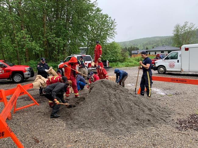
The City of Fernie, which also borders the Elk River, was building up dikes and sandbagging along the river on Tuesday, but it says in a statement that despite sustained rainfall, river levels are at what would be normal for a spring freshet.
Other B.C. areas under evacuation alert include the community of Six Mile, north of Nelson, properties along the Tulameen River, several homes near the Fraser River in Kent, and 27 units in a Sicamous mobile home park that is at the base of a slope considered extremely likely to slide sometime in the next two years.

Flood watches also cover many rivers in the East Kootenay, Cariboo Mountains and their tributaries, the North Thompson River, the Shuswap Region and the Upper Columbia.
This report by The Canadian Press was first published June 14, 2022.
Related Articles
Yellowstone flooding forces 10,000 to leave national park
Advertisement Advertise With Us
Advertisement Advertise With Us