Flood update: No north-side evacuations yet, but listen for the sirens
River's up today; crest could come as early as tomorrow
Advertisement
Read this article for free:
or
Already have an account? Log in here »
We need your support!
Local journalism needs your support!
As we navigate through unprecedented times, our journalists are working harder than ever to bring you the latest local updates to keep you safe and informed.
Now, more than ever, we need your support.
Starting at $15.99 plus taxes every four weeks you can access your Brandon Sun online and full access to all content as it appears on our website.
Subscribe Nowor call circulation directly at (204) 727-0527.
Your pledge helps to ensure we provide the news that matters most to your community!
To continue reading, please subscribe:
Add Brandon Sun access to your Free Press subscription for only an additional
$1 for the first 4 weeks*
- Enjoy unlimited reading on brandonsun.com
- Read the Brandon Sun E-Edition, our digital replica newspaper
*Your next Free Press subscription payment will increase by $1.00 and you will be charged $20.95 plus GST for four weeks. After four weeks, your payment will increase to $24.95 plus GST every four weeks.
Read unlimited articles for free today:
or
Already have an account? Log in here »
Hey there, time traveller!
This article was published 15/05/2011 (5534 days ago), so information in it may no longer be current.
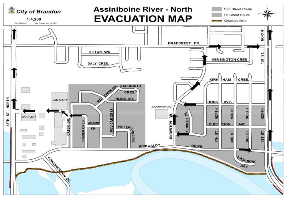
Residents along the north side of the Assiniboine River will be briefed today on their possible evacation, city officials said, but no evacuation has been ordered yet.
Brandon’s emergency warning sirens will be the signal if an evacuation is required.
Evacuation routes have been established for vehicles to proceed out of the area. For residents unable to use a vehicle, plans have also been put in place for public transit to take people out of the area if required.
People in homes north of the river haven’t yet been handed an evacuation order, but the city said that they would be told today of plans and routes just in case an evacuation is required.
The north dike is in good shape and "we’re comfortable enough having people remain there," said emergency coordinator Brian Kayes.
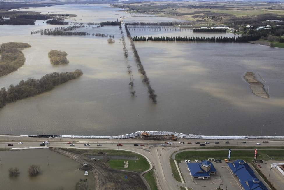
The new evacation planning comes as the Assiniboine River in Brandon is on the rise again. Measured at the First Street Bridge, the river level this morning was about 360.49 metres above sea level.
That’s up about 10 cm from yesterday and only six cm lower than the record river level, set on Tuesday.
However, city officials said at this morning’s flood briefing that they are not expecting "an alarming increase" for the river as it heads towards its peak level.
Yesterday afternoon, provincial flood officials said that they had moved the predicted crest of the Assiniboine forward for Brandon — it’s now expected as early as Monday, May 16, and could stretch to Wednesday, May 18. That’s two days earlier than previously estimated. The river is expected to peak at up to 360.82 metres.
The city says dikes in general are doing well.
"However they do remain guarded," said acting city manager Ted Snure.
More than 1,300 people remain evacuated, mostly from low-lying areas of Brandon south of the river. The mayor said that she has heard from people who are "very concerned" about finances if they can’t work, or have been laid off as result of a business that was also closed due to flood.
The mayor and councillors have been meeting with evacuees.
"I’m amazed at peoples’ ability to cope," said Mayor Shari Decter Hirst.
The city pointed out, too, that U-turns are not allowed at 18th Street and Cumberland Avenue. Drivers are asked to turn right at Clare Avenue and proceed south on the service road back to the traffic lights in order to access 18th Street South.
First Street North is still closed. Officials are talking cautiously about a mid-week opening.
Highway 110 is still closed to all but truck traffic, and is reduced to a single lane, requiring a pilot vehicle.
Related Articles
Evacuation routes set for north-side residents
Advertisement Advertise With Us
Advertisement Advertise With Us